Earlier Home Plans
Plans as of 6/14/05 in pdf format are at the links below. These are the first revision of the plans entered into AutoCad.
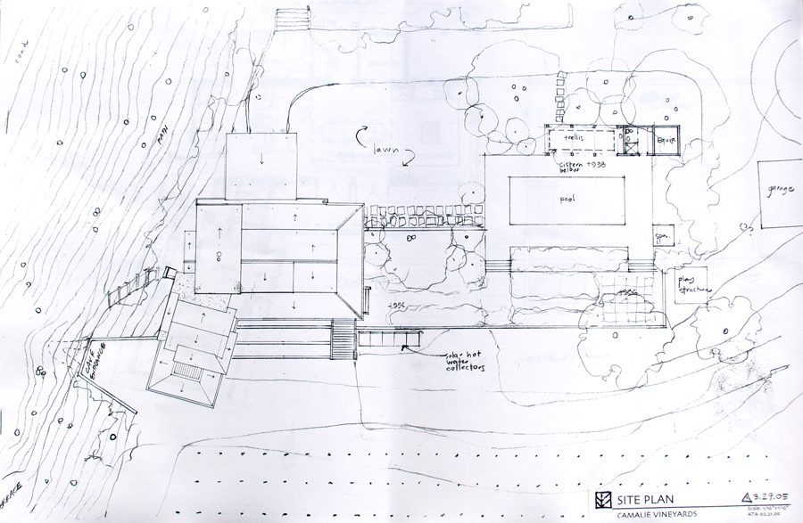
Site Plan
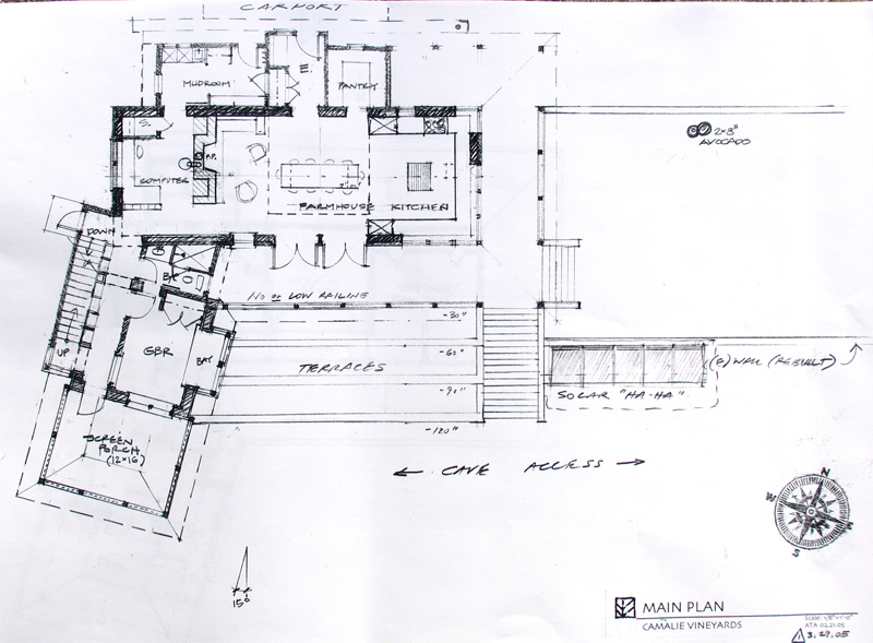
1st Floor Plan
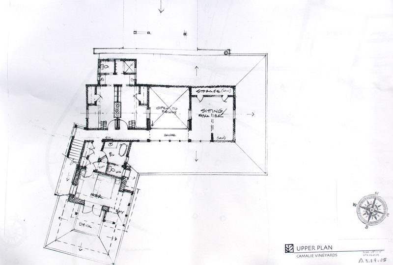
2nd Floor Plan
Basement-Foundation Plan
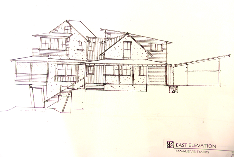
Elevations East and South
Elevations West and North
Kitchen Section from East
Living Room Section
Tower Section
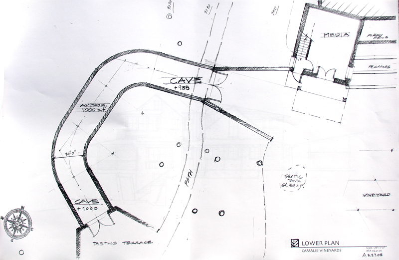
Plans as of 4/20/05. Relatively minor edits relative to 4/1/05 revision except cave design changed substantially.
Elevations and the model photos below are from the 4/1/05 version of the plans.
Plans as of
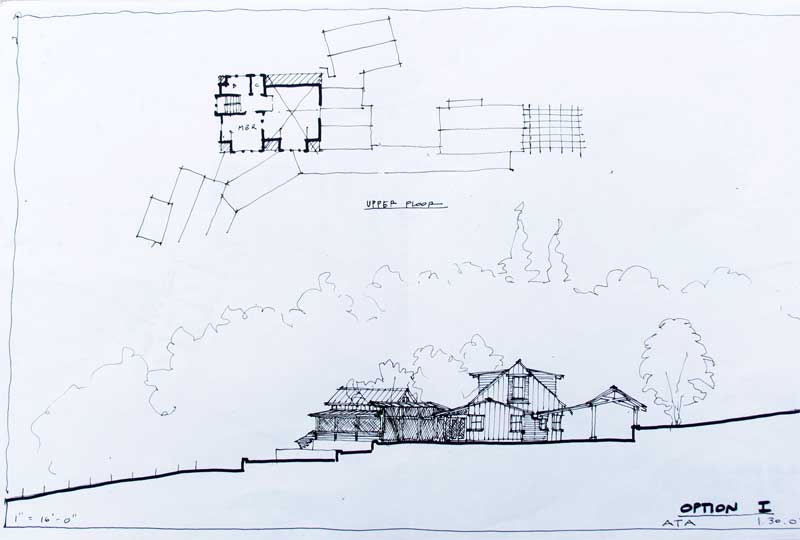
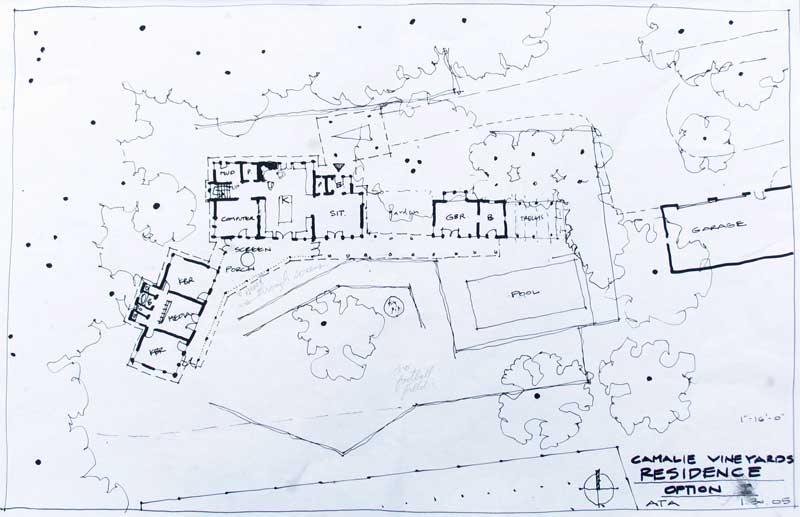
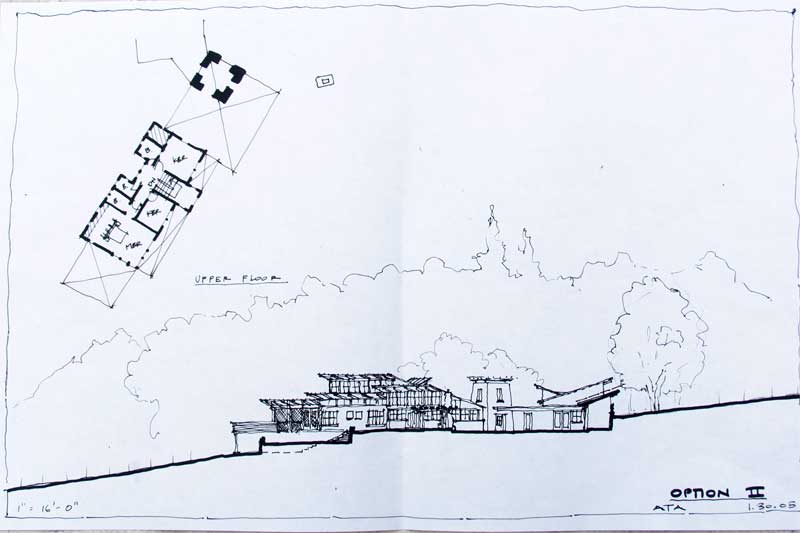
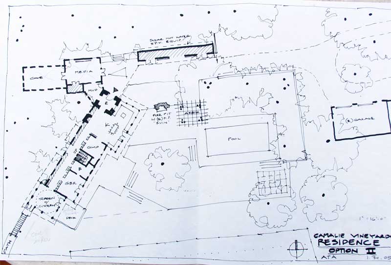
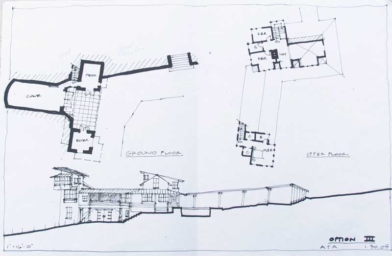
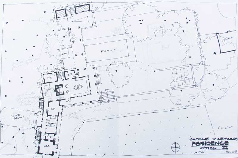
First schematic plans by Arkin and Tilt. 1/29/05 Three options with elevations and floor plans shown for each.
Below is a
document that we put together describing some of the goals of the project.
This document is now fairly old. Sorry the pictures got lost somwhere along the
way when this was transmitted as an e-mail.
 1871 Mt Veeder Landscape General
Description
1871 Mt Veeder Landscape General
Description


|
G |

|
F |

|
E |
|
A |
|
D |
|
C |
|
B |

This
picture is from 2000. A formal survey map is shown at the end of this document.
When we purchased the property in November 2000, the place had not been cared
for much and was overgrown with ivy. We’ve gotten rid of all of the ivy (A)
where it is covering the garage and pretty much everything else there. There is
an old working cistern under the ivy in this picture which has been cleaned up
and is a significant (20%) source of year-round irrigation water for gardens
and orchard. The ancient septic is located at (B). The crumbling sitting wall
is the grayish line marked by (C). We think a swimming pool of some,
to-be-designed flavor might go nicely somewhere along where the current wall is
located. The black rectangle outline might be a good place but we are very open
to alternatives. There is a falling down old pergola (D) with a failing shade
garden under it. There are some large old Camillas along the north edge of the
house and lining the driveway close to the house. They produce copious
quantities of gorgeous Camillas in the late winter. The house area is very
effectively screened from the circular driveway/orchard/ag-yard (E) by a set of
old trees. The ag yard (E) is actively used for tractors, attachments, crawler,
pick-up trucks, etc. as well as party parking. It has some 80+ year old
producing pear trees and some newly planted (last year and this) peach, cherry,
plum and apricot trees. The house and gardens abut the non-native forest (F)
that rises rapidly beside the house. It needs stabilizing. We’ve created a path
through the woods but the oak trees appear to have Sudden Oak Death and several
are falling each year. We need a solution to this problem. The area used to be
redwood trees. We would be happy to have the existing forest/woods become
increasingly redwood. This might offer appeasement to Napa County Permitting
Processes. There is a steep area (G) which is very visible from the current
kitchen window and miserable “guest” bedroom/bath. The (G) area has access to
the beginning of the path through the woods. It currently contains a rock
floored patio and several cherry trees of various health.
View from the sky with a very rough outline
of our 23 acre ranch. About 1 acre is house and gardens plus fruit trees, 4.5
acres in recently replanted vineyard and the remainder is hilly forest or
woods. Several areas of the forest are suffering from many down trees; probably
Sudden Oak Death.
Our ancient septic system must
be replaced and we want to use a greywater system for some of the landscape and
orchard watering that will be necessary. The replacement system that gets
installed in place of the current tank will depend on it.
We have had a perc. test performed and know that it percs poorly. If we do
anything other than plug replace the septic tank, we will need either an
engineered system or a mound system. If we create a system for grey water we
may be able to open up our options. This is critical as we don’t have a lot of
flat space for a mound system.
We have
done a geological survey (30 foot test drilling, etc.). The area is 30 foot of soil,
expansive on the surface (at least) and it is an “ancient landslide”. We have 5 drilled wells and a cistern for a
reliable water supply plus 4.5 acres of vines and numerous fruit trees varying
in age from 80 years old to just-planted this year. We have PG&E
electricity, an older oil-fired furnace but no propane currently. We know we
will need something other than electricity to heat a pool/spa. We also have
plenty of firewood from our ~18 acres of woods adjacent to the house. We have a
very extensive survey around the house, vineyards and the adjacent hillside
near the house. A JPEG of the survey is included at the end of this document. The
place gets 40 inches of rain from about early November through end of March. We
have extensive erosion control on the lower vineyard. We need to address
erosion control on the upper vineyard. During the winter there are several
natural springs which sometimes emit water through June.
Goals
Our
goals both short and long term are to merge with the location in a low
maintenance way, have great entertainment locations, comfortable and inviting
viewing areas and welcoming teenager areas. We want the indoors to be able to
merge with the outdoors at every opportunity. We are likely to remove the
house, re-using materials as possible, and start over. We might be up for
re-doing rooms as we go along since our children are 10 and 7 and we don’t want
to miss time to engage them and their friends with the Napa home. However, the
current foundation is subsiding unevenly (after 80+ years) and certainly not up
to current engineering standards.
1871 Mt Veeder Landscape Work General Outline
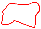
We are unsure of whether to
tear down the house and rebuild it immediately or wait until our kids are
teens. We want the area circled by Red in the above picture to be addressed
first and the area by Blue next.
The Red area includes:
1) Septic
a) Creation of a greywater system to:
i)
Offset the volume the
septic has to deal with; decrease engineering demands
ii)
Increase number of bedrooms supported for least
amount of engineering
iii) Appease the county as possible
iv) Re-use greywater for re-naturalizing the woods areas
with redwoods and/or additional fruit trees
b) Implementation of new system including possibly
moving the “holding tanks” for both grey and black water
2) Pool
a) Complementary to the surroundings
b) Entice kids and teens for visiting and playing
c)
Propane and/or solar heating. Wood?
3) Replace/recover the crumbling rock wall
a) Clear subsidence happening
b) Obvious cracks and leaning
c)
To the east of the walnut tree, create viewing areas
up the valley to the west
d) Retain mature avocado, walnut, lemon and orange trees
as possible
e) Integrate play structure and children’s play area.
They may be moved.
f)
Party area including
use of the wall for seating
The Blue area includes:
1) Stabilizing the hillside
2) Re-naturalizing the forest
3) Part of the beautiful view for the compound
4) Enabling access to the forest path including:
a) Stabilizing the path
b) Naturalizing the path
c)
Enabling possible tasting terrace with cave for the
(probably far) future.
The Orange area includes:
1) Orchard development
2) Party/agricultural parking
3) Covered car entry to house
4)
Shade garden
Implementation
Priority
We
want a plan for all three areas. Implementation priority is first the Red area
followed by the Blue then the Orange area. We want to have the Red area done
ASAP (this year?; code requires hillside mechanical work to occur between April
15 and October 15). Greywater collection and forest edge naturalization to
stabilize the hill would be next (some or all of Blue). The Orange area depends
on our decision regarding the house plans.
Survey Data
Below
is the surveyed data we have so far. The contours were measured by Brooks and
Associates then imported into our Manifold GIS software. The house is at 999
feet elevation as measured by Brooks. The numbered lines are vine rows. The
dashed-X’ed line is deer fence. The forest area is on the deer side of the
fence. We have installed a narrow gate at the entrance to the forest path we’ve
started. The house, gardens and vineyard are inside the deer fence that is
created by the fence on our property and that of our two other neighbors:
Strauss to the north and Domain-Chandon to the east and south. There is a
contiguous deer fence that about 80 acres of grapes depend on to keep deer out.
Our house and gardens benefit from the attention given to the deer fence in
defense of the grapes. While deer have occasionally gotten inside the fence,
they prefer grapes to roses. We got a dog this summer which should further
enhance protection against deer.
The
area to the left of the plot below is the forest which we would like advice on
stabilizing and conversion back to native forest. An earlier owner of the
property harvested redwoods for various things including the columns and
cross-bars on the decrepit pergola still standing on the north of the house.
The redwood trunks inside the pergola columns are probably re-useable.
The
last diagram is an enlargement of the survey work surrounding the house. It
shows all of the existing rock walls and larger trees. The small rectangle
below the wall is the crumbling septic tank. The circle on the right is the
working cistern. Substantial trees up to the dirt road above the house are
surveyed and plotted.